Computerized Mapping and Spatial Data Analysis using ArcGIS Desktop

Computerized Mapping and Spatial Data Analysis using ArcGIS Desktop

( Reviews) Write Review

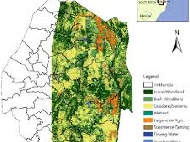
Computerized mapping and spatial data analysis with ArcGIS Desktop (which includes ArcMap and related tools) involves using Geographic Information System (GIS) software to visualize, manage, query, and analyze real-world spatial data to uncover patterns and solve problems. The process uses spatial and attribute data to create maps, perform analyses such as terrain modeling or route finding, and ultimately share insights through maps and reports. 

Event Details

event details

Timings: 00:00

Entry Fee

Ticket Cost

Ticket Cost:

Ticket Cost

Entry both cost costs: N/A

Estimated Turnout

Estimated Turnout: 1000 Visitors

Estimated Turnout

Event type: In-person

Estimated Turnout

Edition: Oct 17

Official Links:

You may like

Mapping and Visualization in Epidemiology and Public Health using GIS and Remote Sensing Technologies
Mapping and Visualization in Epidemiology and Public Health using GIS and Remote Sensing Technologies Kenya
- Reviews
(1)

Mapping and Visualization in...

This course introduces participants to the principles and applications of GIS and RS in the context...
Africa Regional Workshop of the International Association for Social Science Information Services and Technology (IASSIST)
Africa Regional Workshop of the International Association for Social Science Information Services and Technology (IASSIST) Ghana
- Reviews
(1)

Africa Regional Workshop of the...

This significant event brings together professionals from various academic and information institutions to...
Training on Effective Coaching and Mentoring as a Tool to Resolving People Performance Issues
Training on Effective Coaching and Mentoring as a Tool to Resolving People Performance Issues Nigeria
- Reviews
(1)

Training on Effective Coaching and...

The event titled "Training on Effective Coaching and Mentoring as a Tool to Resolving People Performance...